
Troodos-Nature Trails-3
Gouri (Linear) Nature Trail
Of special interest on this trail are the indigenous flora and the traditional soil terraces.
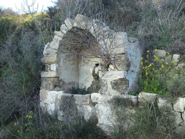
| Start Point: | Gouri village. Access from Nicosia – Gouri main road, towards the cemetery, by the traditional water fountain. |
| Estimated Duration: | 30 minutes |
| Difficulty Rate: | Easy trail, with gentle gradient. Suitable for all ages and fitness levels. |
| Trip Length: | 900 metres |
Doxa si o Theos - Moutti tis Choras (Linear) Nature Trail
Connects with the local area trail network of Doxa si o Theos - Madari and Moutti tis Choras - Selladi tou Karamanli. At the starting point there is a fountain with drinking water.
| Start Point: | Location Doxa si o Theos, 2 kilometres from Kyperounda sanatorium/first aid centre, or 5 kilometres from Spilia village on the Kyperounda - Spilia main road. |
| End Point: | Location Moutti is Choras (1 kilometre from Spilia village towards Agia Eirini/Kannavia villages). |
| Estimated Duration: | 30 minutes |
| Difficulty Rate: | Easy trail, with gentle gradient. Suitable for all ages and fitness levels. |
| Trip Length: | 1,8 kilometres |
Doxa si o Theos - Madari (Linear) Nature Trail
The path connects with the local area trail network of Madari - Selladi tou Karamanli and Doxa si oTheos - Moutti tis Choras. At the starting point there is a fountain with drinking water.
| Start Point: | Location Doxa si o Theos, 2 kilometres from Kyperounda sanatorium/first aid centre, or 5 kilometres from Spilia village on Kyperounda - Spilia main road. |
| End Point: | Madari fire lookout station (Vehicular access from Chandria - Polystypos main road, towards Madari peak) |
| Estimated Duration: | 2 hours |
| Difficulty Rate: | High degree of difficulty. Route with difficult terrain such as sudden changes in gradient (uphill and/or downhill). Unsuitable for young children. |
| Trip Length: | 3,7 kilometres |
Enetika Gefyria (Venetian Bridges) Trail (Linear) Nature Trail
Offering panoramic views throughout, the path takes you past the medieval bridges of Elia, Tsielefos and Roydia.
| Start Point: | Kaminaria village |
| End Point: | Vretsia village |
| Estimated Duration: | 6 hours |
| Difficulty Rate: | High degree of difficulty. Route with difficult terrain such as sudden changes in gradient (uphill and/or downhill). Unsuitable for young children. |
| Trip Length: | 17 kilometres |
Kampos tou Livadiou Trail (Circular) Nature Trail
| Start Point: | Road leading to Kampos tou Livadiou picnic site, situated between Troodos Square and location Karvounas, 1,5 kilometres from Troodos Square and 9 kilometres from Karvounas. |
| Estimated Duration: | 1 hour |
| Difficulty Rate: | Easy trail, with gentle gradient. Suitable for all ages and fitness levels. |
| Trip Length: | 3 kilometres |
Kato Amiantos - Loumata ton Aeton (Linear) Nature Trail
| Start Point: | The main road between Kato Amiantos village and S.E.K. Trade Union summer camping site. |
| End Point: | Amiantos Park |
| Estimated Duration: | 1 hour |
| Difficulty Rate: | Average degree of difficulty, suitable for adults in fair to good fitness levels. |
| Trip Length: | 2,5 kilometres |
Kakokefalos - Mantra tou Kampiou (Linear) Nature Trail
Offering a panoramic view over the surrounding area and towards Mesaoria plain, the trail is rich in natural vegetation.
| Start Point: | Panagia tou Machaira monastery road leading to Kionia peak, about 1 kilometre before Kionia picnic site. Goes past the ruins of an old pen.Panagia tou Machaira monastery road leading to Kionia peak, about 1 kilometre before Kionia picnic site. Goes past the ruins of an old pen. |
| End Point: | Mantra tou Kampiou picnic site |
| Estimated Duration: | 2 hours and 30 minutes |
| Difficulty Rate: | High degree of difficulty. Route with difficult terrain such as sudden changes in gradient (uphill and/or downhill). Unsuitable for young children. |
| Trip Length: | 5,5 kilometres |
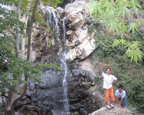
Kalidonia Trail (Linear) Nature Trail
Passing over the picturesque Kalidonia Waterfall, the trail ends at Psilo Dendro, over the village of Pano Platres.
| Start Point: | About 350 metres off the Troodos – Platres main road, 3 kilometres from Troodos Square (Plateia Troodous). Access to the starting point is also possible via the old Troodos – Platres main road, past the Presidential summer house. |
| End Point: | Location Psilo Dendro over Pano Platres village |
| Estimated Duration: | 1 hour and 30 minutes |
| Difficulty Rate: | High degree of difficulty. Route with difficult terrain such as sudden changes in gradient (uphill and/or downhill). Unsuitable for young children. |
| Trip Length: | 3 kilometres |
Kalopanagiotis - Oikos Villages (Linear) Nature Trail
| Start Point: | Kalopanagiotis village, at a downhill point of the main road at the centre of the village, towards the church of Agios Ioannis Lambadistis. |
| End Point: | Oikos village |
| Estimated Duration: | 1 hour and 30 minutes |
| Difficulty Rate: | Average degree of difficulty, suitable for adults in fair to good fitness levels. |
| Trip Length: | 3,8 kilometres |